Roaming UAVs ease airborne border and coastal surveillance.
Enduring territorial disputes, illegal immigration, transnational crime, and domestic and international terrorism in Asia-Pacific continue to drive regional interest in the protection of long and often porous land and maritime boundaries.
While the imperative to monitor national borders is well understood, the reality on the ground for most regional governments is that it is practically impossible to entirely secure the vast land and coastal stretches that separates them from each other.
The size of these boundaries for the largest countries can be staggering. India has over 15,106km (9,386 miles) of shared land borders with seven other countries – with at least three being actively disputed – and 7,516km (4,670 miles) of coastline (including island territories), while Thailand in mainland Southeast Asia has over 4,800km (3,000 miles) of land boundaries with four other countries and over 3,200km (2,000 miles) of coastline.
The traditional approach to border surveillance includes monitoring by fixed cameras, ground sensors, security and patrol vehicles, and manned aircraft. However, there is a growing interest to field unmanned aerial vehicles (UAVs) to boost situational awareness for deployed personnel and vehicles suspicious activity along treacherous terrain and to get a closer look at areas that may be inefficient or unsafe for patrol.
Moreover, larger and more capable UAVs configured specifically for long-endurance missions are increasingly being seen as potential surrogates for costly and resource-intensive manned aircraft or troop deployments. Analysts note that UAVs typically have the advantage over their manned counterparts in these areas: time on station; cost per flight hour; lower risk to human life; and manned-unmanned teaming efficiencies.
Dublin-based market research company Research and Markets noted that the Asia Pacific UAV market will grow at a 2020-2026 compound annual growth rate (CAGR) of 13.8 percent with an addressable cumulative market value of $37.42 billion, largely driven by supportive government and military initiatives across the region as the geopolitical situation continues to deteriorate.
Small but effective
Sensor technology advances mean small tactical UAVs such as the Boeing-Insitu ScanEagle, which is being delivered to several Southeast Asia countries, can now perform land or maritime surveillance tasks previously only possible with larger aircraft.
The ScanEagle UAV is just 1.6m (5.2 feet) long with a wingspan of 3.1m (10ft) and has a maximum take-off weight (MTOW) of around 48 pounds (22 kilograms). Designed to accommodate either a heavy fuel or gasoline engine, the air vehicle is designed to stay aloft for periods of over 24 hours carrying a range of payloads including high-definition electro-optical (EO) or medium-wave infrared (MWIR) sensors, dual imaging EO/IR systems, as well as a growing range of novel sensors.

The UAV is launched from a trailer-mounted pneumatic catapult when operated on land, and a compact low-pressure pneumatic catapult when deployed on board ships. Recovery during maritime surveillance would require the SkyHook system, which secures the UAV in mid-air.
The Republic of Singapore Navy (RSN) has deployed the ScanEagle since 2011 aboard its upgraded Victory-class missile corvettes, which provide the ships with an organic offboard intelligence, surveillance, and reconnaissance (ISR) capability. The service’s success in the type is now being emulated by the naval and maritime forces of at least three other regional countries.
Under the US-sponsored Maritime Security Initiative (MSI), Indonesia, Malaysia, the Philippines, and Vietnam are each in the process of receiving donations of newbuild ScanEagle UAVs to boost their respective maritime patrol capabilities.
In mid-2019 it was announced that Boeing-Insitu had received a $47.9 million contract to supply 34 of these platforms to Indonesia, Malaysia, the Philippines, and Vietnam. The Philippines had earlier benefited from a transfer of six ScanEagle 2 UAVs from the United States in May 2018 and is operated by the Philippine Air Force (PAF) 300 Air Intelligence and Security Wing (AISW).
Working smarter, not harder
Smaller tactical-class UAVs such as the ScanEagle are being improved over time with more capable and ‘smarter’ payloads, which employ machine learning (ML) or even artificial intelligence (AI) technologies to assist the operator in exploiting the vast amounts of data that modern sensors can capture. AI powered by faster processors and in some instances further aided by on-board graphics processing units (GPUs) enable real-time on-board data analysis or ‘edge processing’, which is seen as a more efficient and secure technique of ISR as opposed to streaming data in real-time to remote servers or storing them in the UAV for post-processing after recovery.
For instance, Insitu has partnered with Overwatch Imaging who have integrated a customised TK-5 Firewatch smart tactical mapping payload designed to provide real-time wide-area, high-resolution imagery intelligence for a broad range of applications.
According to a joint statement, the TK-5 Firewatch payload can map an area of over 50,000 acres per hour with resolution much greater than high-altitude or space-based multi-band imaging systems, and features ideal image data and onboard processing capability to enable faster identification and delivery of precision geospatial intelligence at large scale.
The TK-5 Firewatch payload can autonomously collect high-definition imagery in visible, near infrared, and thermal infrared spectral bands simultaneously, and performs on-board analysis using GPU-accelerated processors and advanced computer vision software to provide wide-area image maps for situational awareness, change analysis, and response planning. Smart algorithms, taking advantage of advancements in the field, can process signals and images at rapid speed and can detect anomalies with greater accuracy than human beings.
The ability of UAVs to collect highly detailed images and sensor data quickly also brings about its own challenges. It is also equally important to analyse this information quickly and accurately for effective decision making. High-resolution, high-frame-rate video and image capture also require high-bandwidth communications networks for real-time data sharing while data processing requirements have also increased, calling for high-performance computing systems to process image data and to run complex image analysis algorithms.
Clever Herons
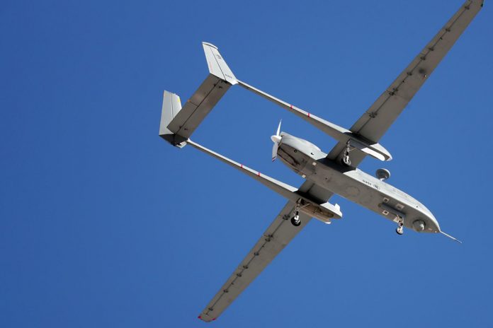
The Republic of Singapore Air Force (RSAF) is also leveraging on AI technology to enhance the effectiveness of its primary ISR platform, the Israel Aerospace Industries (IAI) Heron 1 medium altitude long endurance (MALE) UAV. The service’s Heron 1 UAVs were declared fully operational in March 2017 and are operated by the 119 and 138 Squadrons. These have been deployed to monitor the island state’s sea approaches, and are understood to have be used to observe intruding Malaysian government vessels during a port limit dispute in late 2018.

At Exercise Forging Sabre later in the same year, the Defence Science and Technology Agency (DSTA) debuted an indigenously developed command-and-control (C2) system that integrates the Heron 1’s video feeds into an augmented reality display and supported by advanced video analytics software.

“Using advanced graphics rendering technology, static geographical data such as landmarks, road names, building types, [and] vegetation are overlaid on top of the real-time video captured by the UAV,” said DSTA in a statement. The agency further noted that the integrated display can reduce the cognitive load of the operators and the time they need to orientate themselves to the latest ground situation picture.
“Previously, videos captured by the UAV had to be manually correlated and marked out on a separate static map display,” it added.
A more advanced version of the C2 system was demonstrated at the next edition of Forging Sabre in 2019, with the UAV tasked with performing co-operative lasing to support other airborne and ground-based assets to detect, track, and designate multiple moving targets.
According to the Ministry of Defence (MINDEF), the exercise was the first demonstration of artificial intelligence (AI)-driven decision support software called the Automatic Target Detection (ATD) and Target Look Ahead (TLA) video analytics, which are capable of marking and classifying targets – usually performed manually by RSAF operators – according to their threat level automatically, based on various factors such as the type of weapons they might be carrying.
DSTA engineer and ATD development team member Joshua Lim was quoted by media as saying that the idea for the system came from the realisation that some processes could be automated to help reduce the cognitive burden on personnel. However, he noted that the processing had to be performed without slowdown to ensure that decision makers receive the most up to date video imagery.
High-altitude solutions
The ongoing military standoff at Sino-Indian border has seen China and India developing and fielding specialised equipment that can function effectively in the extreme altitudes that troops and security forces on both sides operate in.
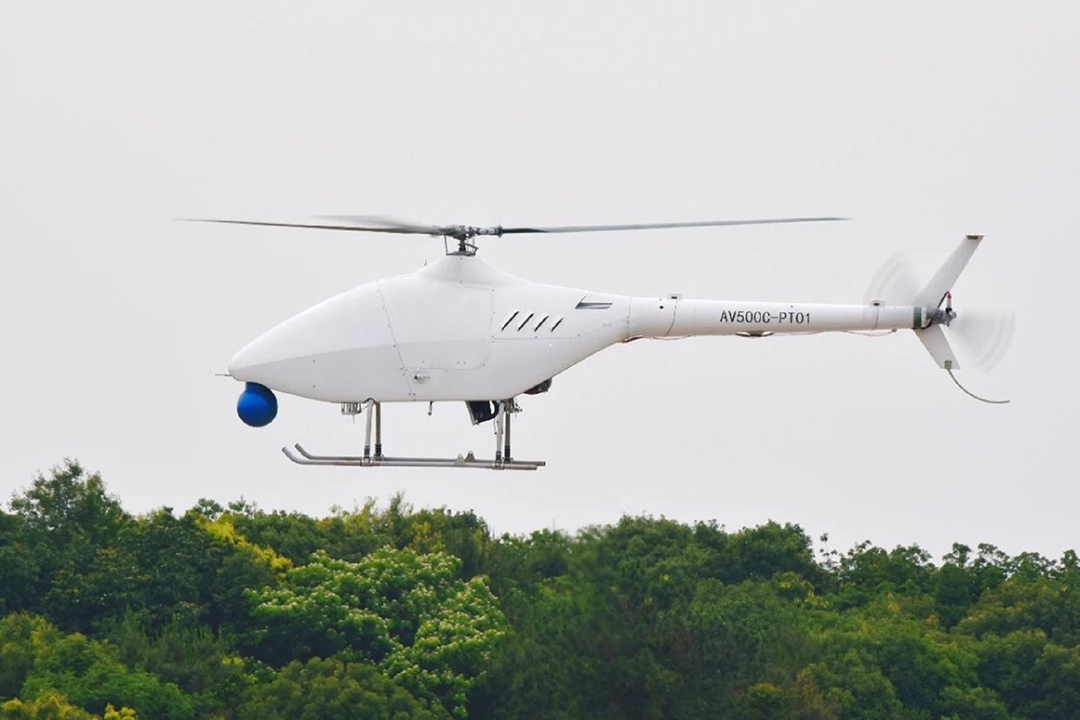
For example, the Aviation Industry Corporation of China (AVIC) is developing a new version of its AV500 rotary wing vertical take-off and landing (VTOL) UAV that has been designed specifically for such extreme environments. The company announced on 21 May that the prototype AR500C had been test flown at its dedicated UAV research and development facility northeastern Jiangxi Province.

The AR500C features a lightweight the carbon fibre reinforced polymer airframe, a more powerful engine, and a new three-bladed main rotor that enables it to attain a service ceiling of 21,980ft (6,700m) when deployed from terrain at altitudes of 16,400ft (5,000m) above sea level. AVIC also said the UAV can operate for up to five hours and achieve a top speed of 92 knots (170km/h).
To reduce operator workload, the UAV features extensive ‘baked-in’ automation such as automatic take-off and landing, automatic hovering, waypoint-based semi-automatic navigation as well as real-time flight re-planning. Other features include AI-driven image and video exploitation tools to speed up sense-making of captured raw data, as well as smart health and usage monitoring functionality to ensure that it performs reliably in those extreme conditions.
by JR Ng


