As tensions escalate between China and Japan in the East China Sea, Japan continues to plan for the deterrence of Chinese aggression in and around the waters of the Senkaku Island region.
Strategies for defending the East China Sea, a place notoriously wrought with antagonistic behavior by bad actors, necessitate greater maritime awareness. HawkEye 360’s Radio Frequency (RF) data and analytics are delivering greater visibility of the Senkaku region, providing partner organizations with valuable insights into dark vessel activity, illegal fishing, encroachment on Economic Exclusion Zones (EEZs), and suspicious rendezvous.
Given a more complete picture of the region using HawkEye 360 data and analytics, Japan and other countries of the region may deploy patrols more efficiently to reduce Chinese attempts to assert control over the disputed islands.
Background
The Senkaku Islands, or Diaoyu Islands to the Chinese, feature sovereignly contested land and surrounding waters with claims from Japan, China, and Taiwan. Each country claims to have economic rights in an EEZ of 200 nautical miles from its coast, but that space overlaps. The Senkakus provide the basis for measuring the EEZ.
The Senkakus are home to diverse plant and animal habitats and desirable fishing grounds. In addition, oil and natural gas reserves are suspected to exist there. Finally, the proximity to prominent shipping routes also makes these islands economically attractive and strategically important.
In 2008, a joint statement of China and Japan affirmed joint responsibility for ensuring peace, stability, and growth in the Asia-Pacific. Since then, China and Japan have repeatedly accused each other of violating their sovereignty. Chinese fishing fleets may be armed and patrolling the waters of the East China Sea, which includes the areas closest to the Senkakus.
RF-First Approach to Maritime Awareness
Through an RF-first approach, HawkEye 360 enables a broad area search for indicators of IUU fishing activity, becoming the tipping source for a comprehensive multi-source analysis. These insights supply intelligence for strategic response and remediation tactics.
Tracking vessels at sea — including location, route, rendezvous, and maritime events — is important for national security. HawkEye 360 monitors marine RF activity over an immense field of view, offering rapid revisits of the entire South and East China seas. The unique RF data can pinpoint hotspots of disconcerting vessel activity, so authorities can quickly task other resources such as EO imagery, UAVs, or Coast Guard patrols.
Illegal, Unreported, and Unregulated (IUU) fishing is a global concern. Cooperative vessels broadcast AIS data as required by international law, but if a vessel ceases to broadcast its position, it disappears from common tracking tools. Some of the most egregious acts of IUU fishing each year take place in the South and East China seas when vessels attempt to hide their activity by not broadcasting AIS. However, HawkEye 360’s RF geolocations can find these dark vessels by using a range of UHF, VHF, L-Band, X-Band, and S-Band signals.
China reportedly possesses the world’s largest fishing fleet, providing subsidies to large vessels that can cover a great distance and harvest massive amounts of fish. When working together in fleets, these vessels often cause grave impacts on the marine environment and can intimidate smaller fishing vessels. These vessels require careful monitoring to make sure they are compliant, especially when operating in disputed regions such as the Senkaku Islands.
During the high fishing season, HawkEye 360 examined vessel activity around the Senkakus. Class-B AIS records showed many Chinese-flagged fishing vessels within the disputed region, and RFGeo signal data pointed out sites of UHF activity originating in multiple locations where there were no AIS signals (Image 1).

HawkEye 360 identified sites where Chinese fishing vessels were likely emitting UHF signals (Image 1, Site A). These signals were fairly unique, suggesting the vessels were using alternative UHF push-to-talk radios to coordinate activities instead of standard VHF maritime radios.
During Fall 2021, HawkEye 360 geolocated UHF signals from several places around the claimed Japanese region of the Senkakus, indicating the presence of Chinese fishing vessels (Site A) and then using those signals to discover dark vessel activity at Site B.
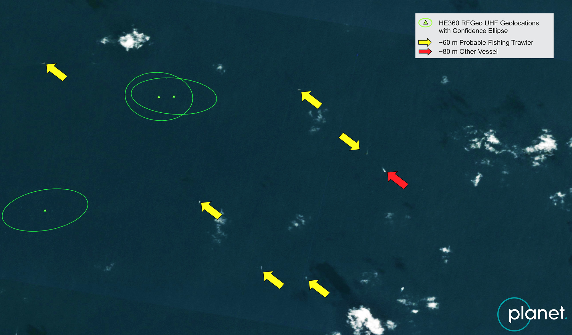
HawkEye 360 leveraged this information to analyze a second site also emitting UHF signals (Image 1, Site B). Site B had a gap in AIS signals, seemingly without vessel presence. But HawkEye 360’s RFGeo signals pointed to similar communication signals as seen at Site A, potentially indicating dark Chinese fishing vessels. Planet imagery for Site B provided further evidence of multiple dark fishing trawlers. (Image 2).

A Common Thread
China continues to exert influence over vessels in the East China Sea, laying claims to greater areas of sea and land, sometimes taking advantage of the escalated tensions. Japan tracked an alarming increase in Chinese Coast Guard and maritime militia activity around the Senkakus and has consistently protested activities. In July 2022, Japan also formally reported a pair of Chinese Coast Guard vessels that chased a Japanese fishing boat through the 12-nautical-mile waters.
Fishery agreements between China and Japan extend to vast areas in the South and East China seas – though not the contested area around Senkaku. In August 2021, Japan informed China that fishing vessels are not allowed to operate without permission in these waters. The Japanese Coast Guard issued more than 80 exclusion orders to Chinese fishing vessels suspected of illegally operating in Japanese waters in the Senkaku region alone as of April 2021. Still, China launched more than 10,000 fishing vessels in the East China Sea that year, leaving Japanese fishermen fearful and leading to a marked decline in the Japanese fishing industry.
Greater transparency into regional activity is critical to any strategy deterring China from further aggression. Since AIS is not effective at finding dark vessels, countries need improved maritime domain awareness tools. With HawkEye 360’s RF data, Asia Pacific nations can develop a more complete picture of the region and direct patrols to better monitor China’s illegal fishing activity.


